Tennessee State Parks Make Trails Easier to Navigate
Tennessee State Parks just made it a whole lot easier to plan your next outdoor adventure. They’ve rolled out new trail signs and online information at several parks across the state. Following in the footsteps of the National Park Service, visitors now get detailed information about trail grade, slope, width, surface type, and obstacles — all the specifics that help you decide which trail fits your needs before you even step foot on it.
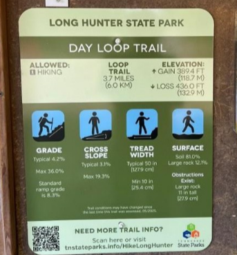
Photo Credit from TN Department of Environment and Conservation
For visitors using wheelchairs or reserving all-terrain chairs (available at many parks at no cost), this information is a game-changer. No more guesswork, no surprises — just a clear picture of what each trail offers.
The update is powered by the High-Efficiency Trail Assessment Process (HETAP), a technology-first system that measures trail length, grade, and potential obstructions. Tennessee is the first state to use HETAP this way, as part of TDEC’s Access 2030 initiative, which aims to make Tennessee the most accessible state park system in the nation. The Tennessee State Parks Conservancy helped make it happen by purchasing one of the HETAP units to support the effort.
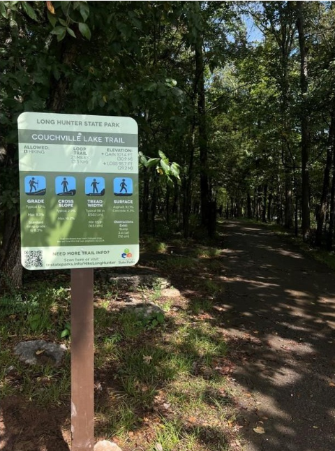
Photo Credit from TN Department of Environment and Conservation
These new signs also reflect elements I discussed earlier in my blog about clear signage. Bold fonts, high-contrast colors, and pictograms make the information easy to understand at a glance. QR codes linked for additional information provide alternative ways to access key details., I would love to see if the signs also provide audio tours and/or can accommodating a wide range of sensory or learning needs.
Ideally, this information shouldn’t just live on a land manager’s website — it should be part of a system that helps users easily choose a trail that fits their abilities. Not every visitor with a disability can intuitively understand what a 5% grade feels like or how a 2% cross slope might affect them. Gathering detailed trail data, as Tennessee has done, is a crucial first step, but the next step is equally important: categorizing and presenting that information in a way that’s meaningful to users. I also recommend providing a dedicated flyer or guidebook with additional context, such as tricky sections, points of historical interest, or other details that help visitors feel informed and welcome.
Accessible trails aren’t just a nice-to-have; they’re a way to make outdoor recreation welcoming for everyone. With detailed signage and thoughtful design, Tennessee State Parks is setting a new standard for inclusive outdoor experiences — making it easier than ever to explore, plan, and enjoy the beauty of nature. This is something that all land managers can accomplish.